Posts

Showing posts from May, 2017

Tres Rios Wetlands

Image
Down in the southern and western section of Phoenix, AZ, sits 500 acres of pristine land known as the Tres Rio Wetlands.   The manufactured property is next to the Estrella Mountains and where you will find Great Blue Herons, beavers and bobcats that roam freely throughout the land.   The sanctuary for native trees, wetland vegetation and animals was constructed as a proficient way to eradicate nitrogen from the wastewater running from the sewage treatment plant which sits next to the refuge. Many of these wetlands, marshes or riparian are located around the world.   They aid in flood control while providing a place for many different animals and water-rooted plants/trees to thrive.   There are at least 1,000 of these engineered wetlands all over the country.   Most of them are located in the southwest where reclaimed water flows for irrigation of non-edible crops such as cotton.    With its many indigenous trees, wildlife, birds and mammals, the Tres Rios Wetlands draws many

The Domes: We All Fall Down

Image
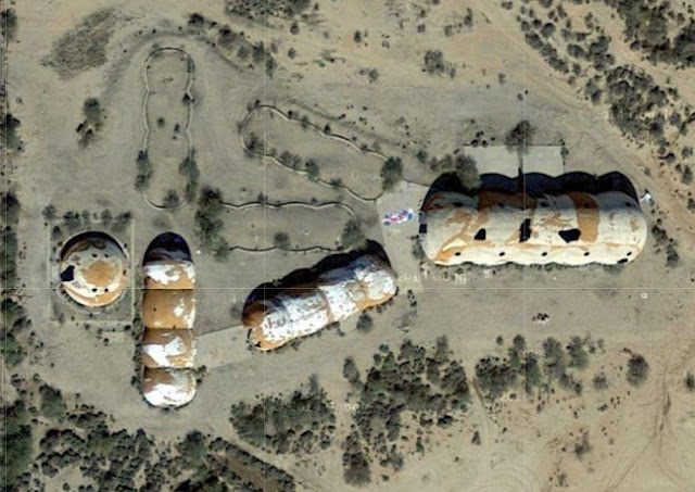
A view from above several years ago. 2010 I have been to the Domes a couple of times.  The back dome was unsafe and crumbling back in 2010.  I am not surprised that it finally collapsed.  I found a video of what it looks like now from a witness of its demise.  I posted the history of the domes.  Here is the link: http://www.echoesofthesouthwest.com/2010/09/secrets-of-domes.html https://youtu.be/xr4R1a24Lmg TristansAdventures

Goat Canyon Trestle

Image
Parts of California are like Arizona with the harsh weather, poisonous critters, and sandy grounds.   In the early 1900’s, San Diego was looking for a faster way to travel to the lively town of El Centro which was the most prevalent settlement in Imperial County.   Along with the other features of Anza-Borrego Desert, stands a massive bridge which extends across the Carrizo Gorge.   The railway passage was named the Goat Canyon Trestle but denoted “The Impossible Railroad” by many naysayers.   By 1919, the insufferable railroad was finished and ready for use. It wasn’t an easy task to operate through the assemblage of 17 tunnels and 14 key trestles arching within the Goat Canyon in Carrizo Gorge.   The final length was 11 miles and it took 12 years to finish.   The massive viaduct was 200 feet tall, loved by railroad fanatics, and a huge achievement.   Alas, the immense structure couldn’t withstand the brutal winds of hurricane Kathleen.   She tore through that gorge crumpling

Atomic Cannon

Image
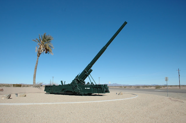
“Yuma, Arizona Atomic cannons, designed and deployed at the white-hot height of the Cold War (1953-1963) but never fired in battle, are displayed at a number of military installations and museums in the US. The intent of the 280mm cannon was to hurl a nuclear shell a tactical distance so the artillery crew -- which took cover during firing in slit trenches -- wouldn't be killed by blast and radiation, the Atomic Cannon resides in that sweet spot between nightmarish nuclear missiles and really dumb atomic hand grenades. An Atomic cannon was test fired in 1953 in Nevada. The Yuma Proving Ground, north of the city of Yuma, offers easy viewing of an M65 280mm atomic cannon at the entrance gate, along with other retired weaponry that includes tanks, rockets, and a 200mm gun-howitzer.”   (From www.roadsideamerica.com website) Read more about it on their website:   http://www.roadsideamerica.com/story/2102

Old Plank Road

Image
I always love it when I discover unusual things about Arizona and its surrounding states.   I was watching a show about abandoned places and structures on the Science channel.   They noted the history of how these things began, and what happened to them.   I thought the story about the OldPlank Road was fascinating. The Old Plank Road was constructed in 1915 by a businessman and road builder “Colonel” Ed Fletcher.   It stretched over the Algodones Dunes in an east-west direction from southern California into Arizona.   Basically, it was the means of travel between San Diego and Yuma. In the early 1900’s, San Diego wanted to be known as the pivotal part of the southern California’s roadways since Los Angeles was the last stop for the transcontinental railroad.   Ed Fletcher was called to task by the Los Angeles Examiner, and was up for the undertaking.   In October of 1912, he and a reporter would run a road race to determine what was going to be the finest path to take between